Wie schreibe ich ein GRASS GIS Addon?
Bewährte Praktiken, Methoden und Werkzeuge

Carmen Tawalika - mundialis - FOSSGIS 2024
mundialis GmbH & Co. KG
- Freie Daten mit freier Software aus Bonn
- Entwicklung von actinia, GRASS GIS und Addons, QGIS Plugins, ...
- Einzelbaumerkennung, Waldklassifikation, Erkennung von versiegelten Flächen, ...
- mundialis.de
info@mundialis.de
github.com/mundialis


Inhalt
.
# Einführung
Die Modularität von GRASS GIS

- Module und Addons als Bausteine
- 542 offizielle GRASS GIS Module (15.3.24, 8.4)
- Weitere offizielle Addons
- Unzählige (und momentan unauffindbare*) weitere Addons
Wozu ein eigenes Addon entwickeln?
- Zusammenspiel und Verkettung mit bestehenden Tools
- Effiziente Nutzung der GRASS Datenbank
- Nutzung in actinia
- Einhaltung von Standards erhöht die Wiederverwendbarkeit
- ...
Minimalversion
- Benennung je nach Familie: v.ector, r.aster, t.ime, i.magery, ...
- d, db, g, i, m, ps, r, r3, t, test, v
- hier absolute Grundlagen zum installieren - Wichtige Bausteine fehlen noch!
Python Skript (C auch möglich)
#!/usr/bin/python

def main():
    print("Created simple addon")


if __name__ == "__main__":
    main()
Ordnerstruktur
t.fossgis.fortune/
├── Makefile
├── t.fossgis.fortune.html
└── t.fossgis.fortune.py
MODULE_TOPDIR = ../..
PGM = t.fossgis.fortune
include $(MODULE_TOPDIR)/include/Make/Script.make
default: script
## Installation mit g.extension
---
GRASS nc_spm_08/fossgis:~ > g.extension extension=t.fossgis.fortune url=t.fossgis.fortune
Compiling...
Installing...
Updating extensions metadata file...
Updating extension modules metadata file...
WARNING: No metadata available for module 't.fossgis.fortune': 'bytes'
object has no attribute 'encode'
Installation of <t.fossgis.fortune> successfully finished
Aufruf
---
GRASS nc_spm_08/fossgis:~ > t.fossgis.fortune
Created simple addon
# Konzepte
# und
# Praxis
Vorgehen
- Abgucken oder kopieren, z.B. v.example
- Anleitung befolgen, z.B. How-to-create-a-GRASS-GIS-addon.md
v.example --> umbenennen
├── .flake8
├── .git [...]
├── .github
│   └── workflows
│       └── linting.yml
├── .pre-commit-config.yaml
├── .pylintrc
├── .pylintrc_allowed_to_fail
├── Makefile
├── README.md
├── renovate.json
├── testsuite
│   ├── data
│   │   ├── README.md
│   │   └── area_beuel.geojson
│   └── test_v_example.py
├── v.example.html --> umbenennen
├── v.example.py --> umbenennen
└── v_example.png
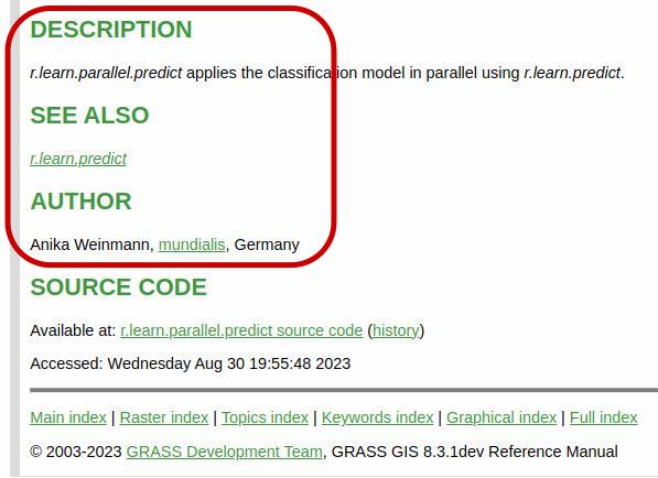
1. Dokumentation
- t.fossgis.fortune.html anpassen und um ausführliche Beschreibung ergänzen
- auch gerne mit Bildern versehen (v.example.png)
<h2>DESCRIPTION</h2>
<em>t.fossgis.fortune</em>
prints fortune cookie sayings.

<h2>SEE ALSO</h2>
<em>
<a href="g.message.html">
g.message</a>
</em>

<h2>AUTHOR</h2>
Carmen Tawalika, mundialis, Germany

## 2. Shebang-Zeile und Header
- Shebang-Zeile und Header inklusive Autor, Zweck und Lizenz in t.fossgis.fortune.py ergänzen
---
#!/usr/bin/env python3
"""
############################################################################
#
# MODULE: t.fossgis.fortune
# AUTHOR(S): Carmen Tawalika
#
# PURPOSE: Prints fortune cookie sayings
# COPYRIGHT: (C) 2024 by mundialis GmbH & Co. KG and the GRASS Development
# Team
#
# This program is free software; you can redistribute it and/or modify
# [...]
# GNU General Public License for more details.
#
#############################################################################
"""
- Die "Kommentare"
# %sind wichtig für den GRASS Parser! - Es gibt
module,option,flagundrules - Es gibt einige Standardoptionen, die erweitert werden können
- Mit
ruleskönnen Bedingungen für Parameter bestimmt werden - Die Parameter können in der main Funktion eingelesen werden, z.B.
options['input'] - Beispielaufruf:
t.fossgis.fortune input=elevation
3. Der GRASS Parser
# %Module
# % description: Prints fortune...
# % keyword: general
# % keyword: fortune
# %end

# %option G_OPT_V_INPUT
# % key: input
# % required: no
# % description: Polygon to...
# %end

# %option
# % key: box
# % description: Width and height
# % type: double
# % answer: 10,10
# % required: yes
# %end

# %flag
# % key: v
# % description: Print fortune...
# %end

# %rules
# % requires: input,box
# %end

4. main.py und cleanup
def main():ist erforderlich und liest alle Parameter ein (z.B.options['input'])- Beliebig viele Zusatzfunktionen sind möglich
- Der GRASS Parser muss vor dem Aufruf der main Funktion aufgerufen werden
if __name__ == "__main__":
    options, flags = grass.parser()
    atexit.register(cleanup)
    main()
def cleanup():
"""Cleanup function (can be extended)"""
nulldev = open(os.devnull, "w", encoding="utf-8")
kwargs = {"flags": "f", "quiet": True, "stderr": nuldev}
for rmvec in rm_vec:
if grass.find_file(name=rmvec, element="vector")["file"]:
grass.run_command("g.remove", type="vector", name=rmvec, **kwargs)
## 5. grass.script
- Nutzung von vorgefertigten Funktionen aus [GRASS GIS source code](https://grass.osgeo.org/grass83/manuals/libpython/script.html)
- Nutzung von existierenden Modulen
- i18n
---
import grass.script as grass
try:
from fortune import fortune
except:
grass.fatal(_("No fortune"))
grass.message(_(fortune()))
---
kachel = grass.parse_command(
"v.db.select", map=overlay, columns="cat", flags="c", quiet=True)
grass.run_command(
"v.extract", input=overlay, output=f"{options['output']}_{kachel}", cats=kachel)
Zwischenstand
import grass.script as grass

try:
    from fortune import fortune
except:
    grass.fatal(_("No fortune"))

def main():
    grass.message(_(fortune()))


if __name__ == "__main__":
    options, flags = grass.parser()
    atexit.register(cleanup)
    main()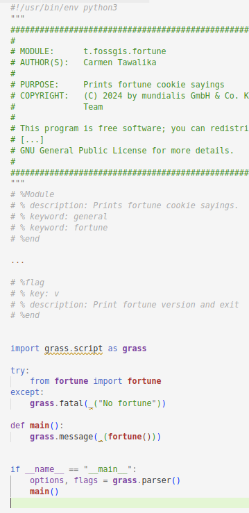
Zwischenstand
GRASS nc_spm_08/fossgis > g.extension extension=t.fossgis.fortune url=t.fossgis.fortune
WARNING: Extension <t.fossgis.fortune> already installed. Re-installing...
[...]
Installation of <t.fossgis.fortune> successfully finished
GRASS nc_spm_08/fossgis > t.fossgis.fortune --help
Prints fortune cookie sayings.
Usage:
t.fossgis.fortune [-v] [input=name] [box=value] [--help] [--verbose]
[--quiet] [--ui]
Flags:
-v Print fortune version and exit
Parameters:
input Name of input vector map
box Width and height
default: 10,10GRASS nc_spm_08/fossgis > t.fossgis.fortune
Sanity and insanity overlap a fine grey line.
# Qualitätssteigerung und Arbeitserleichterung
Wiederverwendbare GitHub Worflows
- mundialis/github-workflows
- Linting
[flake8]
# E402 module level import not at top of file
# F821 undefined name '_'
exclude = .git
max-line-length = 80
per-file-ignores =
    ./v.example.py: F821, E402
name: Python Flake8, black and pylint code quality check
on: [push, pull_request]
jobs:
lint:
uses: mundialis/github-workflows/
.github/workflows/linting.yml@main
t.fossgis.fortune
├── .flake8
├── .git [...]
├── .github
│   └── workflows
│       └── linting.yml
├── .pre-commit-config.yaml
├── .pylintrc
├── .pylintrc_allowed_to_fail
├── Makefile
├── README.md
├── renovate.json
├── testsuite
│   ├── data
│   │   ├── README.md
│   │   └── area_beuel.geojson
│   └── test_v_example.py
├── t.fossgis.fortune.html
├── t.fossgis.fortune.py
└── t.fossgis.fortune.png
Wiederverwendbare GitHub Worflows
- mundialis/github-workflows
- pre-commit Hooks fürs Linting
- Auto-update workflow Version (renovate)
repos:
-   repo: https://github.com/mundialis/github-workflows
    rev: 1.0.3
    hooks:
    -   id: linting
{
"$schema": "https://docs.renovatebot.com/
renovate-schema.json",
"extends": [
"config:base"
],
"pre-commit": {
"enabled": true
}
}t.fossgis.fortune
├── .flake8
├── .git [...]
├── .github
│ └── workflows
│ └── linting.yml
├── .pre-commit-config.yaml
├── .pylintrc
├── .pylintrc_allowed_to_fail
├── Makefile
├── README.md
├── renovate.json
├── testsuite
│ ├── data
│ │ ├── README.md
│ │ └── area_beuel.geojson
│ └── test_v_example.py
├── t.fossgis.fortune.html
├── t.fossgis.fortune.py
└── t.fossgis.fortune.png
Wiederverwendbare GitHub Worflows
name: Run tests for GRASS GIS addons
on:
push:
branches: [ main ]
pull_request:
branches: [ main ]
jobs:
tests:
uses: mundialis/github-workflows/.github/
workflows/grass-tests.yml@grass-tests
# set NC_TEST_DATA to 'NC' for using
# NC GRASS GIS sample location
with:
NC_TEST_DATA: 'NC'
t.fossgis.fortune
├── .flake8
├── .git [...]
├── .github
│   └── workflows
│       └── linting.yml
├── .pre-commit-config.yaml
├── .pylintrc
├── .pylintrc_allowed_to_fail
├── Makefile
├── README.md
├── renovate.json
├── testsuite
│   ├── data
│   │   ├── README.md
│   │   └── area_beuel.geojson
│   └── test_v_example.py
├── t.fossgis.fortune.html
├── t.fossgis.fortune.py
└── t.fossgis.fortune.png
## grass-gis-helpers
- Python Bibliothek [grass-gis-helpers](https://github.com/mundialis/grass-gis-helpers)
- Auslagerung von in GRASS GIS Addons häufig verwendeten Funktionen
- Verbessern der Dokumentation zur Wiederverwendbarkeit
- Cleanup Funktionen für spezielle Use Cases
- Paralleles Prozessieren
- Validierungsmethoden
- ...
- Contributions welcome!
---
def check_valid_rasterdata(input, strict=True):
def get_location_size():
# Wrap it up
- Minimalversion (Makefile, HTML, Python)
- Abgucken / Kopieren [v.example](https://github.com/mundialis/v.example)
- Anleitung befolgen [How-to-create-a-GRASS-GIS-addon.md](https://github.com/mundialis/grass-gis-helpers/blob/main/How-to-create-a-GRASS-GIS-addon.md)
- 1. Dokumentation in HTML-Datei
- 2. Shebang-Zeile und Header
- 3. Der GRASS Parser [g.parser](https://grass.osgeo.org/grass-devel/manuals/g.parser.html)
- 4. main.py und cleanup
- 5. Verwendung von grass.script
- Wiederverwendbare GitHub Worflows [mundialis/github-workflows](https://github.com/mundialis/github-workflows)
- Linting (Workflow & pre-commit)
- Test Worflow
- [mundialis/grass-gis-helpers](https://github.com/mundialis/grass-gis-helpers)
# Addons von mundialis
- [mundialis/grass-addons](https://mundialis.github.io/grass-addons/) (38 Repositories*, grass-gis-helpers)

## GRASS GIS Addons von mundialis
__[grass-keyhole](https://github.com/mundialis/grass-keyhole)__
- Keyhole Satellitenprogramm von 1959 bis 1972
- Orthorektifizierung alter Spionagesatellitenbilder
- Zusammensetzen einer Szene aus Einzelscans
- Sammeln von Kontroll-Punkten (GCP)
- Orthorektifizierung
- siehe auch "Das Beste der 60er, 70er und 80er: hochauflösende Spionagesatellitenaufnahmen" FOSSGIS 2023, Vortrag von M. Metz


## GRASS GIS Addons von mundialis
__[r.geoserver](https://github.com/mundialis/r.geoserver)__
- Nutzung der GeoServer REST API
- Publizieren von
- Raumzeitwürfeln als GeoTIFF/Image Mosaic (t.geoserver.publish)
- Rasterkarten und Raumzeitwürfeln im [geoserver-grass-raster-datastore](https://mundialis.github.io/geoserver-grass-raster-datastore/) (r.geoserver.publish)
- Upload eines GRASS GIS Stils und Verknüpfung mit einem Layer (r.geoserver.style)

## GRASS GIS Addons von mundialis
__[v.alkis.buildings.import](https://github.com/mundialis/v.alkis.buildings.import)__
- Herunterladen von ALKIS-Gebäudedaten und Import in GRASS GIS
- Download per Bundesland
- Mögliche Bundesländer bisher:
- Baden-Würrtemberg (nur lokaler Import)
- Berlin
- Brandenburg
- Hessen
- Nordrhein-Westfalen
- Sachsen
---
v.alkis.buildings.import output=alkis_buildings federal_state=Nordrhein-Westfalen -r